

I was first introduced to the Nazca Lines when my Dad shared with me a book he had been reading…Chariots of the Gods by Eric Von Daniken. This would have been sometime around the late 1960’s when UFO’s, Aliens and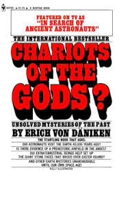 Pyramid Power were of interest to many people. My Dad was a voracious reader and in his retirement, visiting the Public Library was one of his main passions. He would bring home the most interesting books which we would often discuss during those long dark winter evenings.
Erik von Daniken was a Swiss author of several books which makes claims about the influence of aliens on early human culture. His book, Chariots of ther Gods, was published in 1968 and brought the Nazca Lines to public prominence with his proposal that the lines were built on instructions from extraterrestrial beings as airfields for their spaceships Since that time most of his theories have been debunked by scientists as pseudo-archaeology and pseudo-science.
If my memory is correct, he or someone speaking about his theories, visted Edmonton to give a talk and it was likely held at the Queen Elizabeth Planetarium. Years later, I would be drawn to the Telus World of Science to volunteer for the Body Worlds Exhibit (2008). They are now in the process of restoring this neglected sit to its former glory and it will serve other purposes.

Strange, isn’t it, how somethings we encounter in our early lives keep cropping up over time.
You are problably wondering why I am writing about this topic. Well, yesterday I was couch surfing and came across the DTOUR Channel which was showing Expeditions Unknown. Josh Gates was checking into the mysteries of the Nazca Lines and talking about some of the modern theories as to the reasons for their exisitence. Having just flown over the Lines on a trip I made to Peru in March 2017, I was intrigued by what the show might have to say and if it would enhance my understanding of what I saw on the plane ride over the lines.

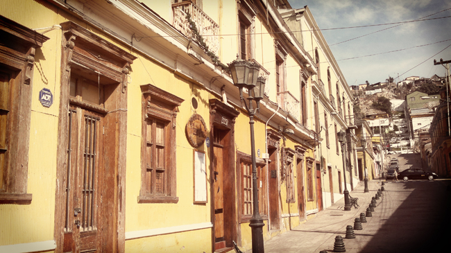
Airport at Nazca

Sandra and Jubo getting read for the flight


So much to take in…lines, spirals, animal glyphs..
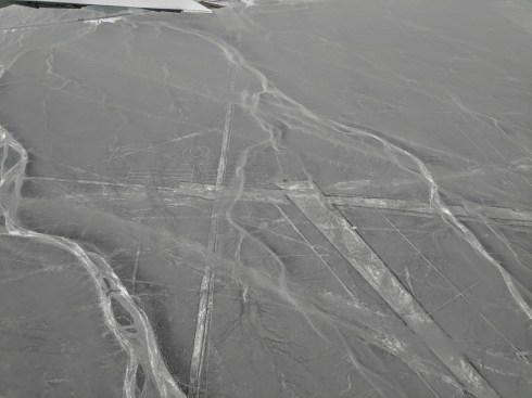
What is it I am seeing?
The following is an article by Jason Golomb in National Geographic…he says it better then I ever could to provide an explanation.
“As a plane soars over the high desert of southern Peru, the dull pale sameness of the rocks and sand organize and change form. Distinct white lines gradually evolve from tan and rust-red. Strips of white crisscross a desert so dry that it rains less than an inch every year. The landscape changes as lines take shape to form simple geometric designs: trapezoids, straight lines, rectangles, triangles, and swirls. Some of the swirls and zigzags start to form more distinct shapes: a hummingbird, a spider, a monkey.
These are the renowned Nasca Lines, subject of mystery for over 80 years. How were they formed? What purpose could they have served? Were aliens involved?
The lines are found in a region of Peru just over 200 miles southeast of Lima, near the modern town of Nasca. In total, there are over 800 straight lines, 300 geometric figures and 70 animal and plant designs, also called biomorphs. Some of the straight lines run up to 30 miles, while the biomorphs range from 50 to 1200 feet in length (as large as the Empire State Building).
THE LINES REVEALED
Peruvian archaeologist Toribio Mejia Xesspe was the first to systematically study the lines in 1926. However, since the lines are virtually impossible to identify from ground level, they were only first brought to public awareness with the advent of flight—by pilots flying commercial planes over Peru in the 1930s. American professor Paul Kosok investigated and found himself at the foot of a line on June 22, 1941—just one day after the winter solstice. At the end of a full day studying the lines, Kosok looked up from his work to catch the sunset in direct alignment with the line. Kosok called the 310 square mile stretch of high desert “the largest astronomy book in the world”.
Kosok was followed by the German Maria Reiche, who became known as the Lady of the Lines. Reiche studied the lines for 40 years and fought unyieldingly for her theories on the lines’ astronomical and calendrical purpose (she received a National Geographic grant in 1974 for her work). Reiche battled single-handedly to protect the site; she even lived in a small house near the desert so she could personally protect the lines from reckless visitors.
WHAT ARE THE LINES?
The lines are known as geoglyphs – drawings on the ground made by removing rocks and earth to create a “negative” image. The rocks which cover the desert have oxidized and weathered to a deep rust color, and when the top 12-15 inches of rock is removed, a light-colored, high contrasting sand is exposed. Because there’s so little rain, wind and erosion, the exposed designs have stayed largely intact for 500 to 2000 years.
Scientists believe that the majority of lines were made by the Nasca people, who flourished from around A.D. 1 to 700.
Certain areas of the pampa look like a well-used chalk board, with lines overlapping other lines, and designs cut through with straight lines of both ancient and more modern origin.
THE THEORIES
The Kosok-Reiche astronomy theories held true until the 1970s when a group of American researchers arrived in Peru to study the glyphs. This new wave of research started to poke holes in the archeo-astronomy view of the lines (not to mention the radical theories in the ‘60s relating to aliens and ancient astronauts).
Johan Reinhard, a National Geographic Explorer-in-Residence, brought a multidisciplinary approach to the analysis of the lines: “Look at the large ecological system, what’s around Nasca, where were the Nasca people located.” In a region that receives only about 20 minutes of rain per year, water was clearly an important factor.
“It seems likely that most of the lines did not point at anything on the geographical or celestial horizon, but rather and fertility of led to places where rituals were performed to obtain water crops,” wrote Reinhard in his book The Nasca Lines: A New Perspective on their Origin and Meanings.
Anthony Aveni, a former National Geographic grantee, agrees, “Our discoveries clearly showed that the straight lines and trapezoids are related to water … but not used to find water, but rather used in connection with rituals.”
“The trapezoids are big wide spaces where people can come in and out,” says Aveni. “The rituals were likely involved with the ancient need to propitiate or pay a debt to the gods…probably to plead for water.”
Reinhard points out that spiral designs and themes have also been found at other ancientPeruvian sites. Animal symbolism is common throughout the Andes and are found in the biomorphs drawn upon the Nasca plain: spiders are believed to be a sign of rain, hummingbirds are associated with fertility, and monkeys are found in the Amazon—an area with an abundance of water.
“No single evaluation proves a theory about the lines, but the combination of archeology, ethnohistory, and anthropology builds a solid case,” says Reinhard. Add new technological research to the mix, and there’s no doubt that the world’s understanding of the Nasca lines will continue to evolve.”
Another article available on the internet is from the Khan Academy website…
Khan Academy is a non-profit educational organization created in 2006 by educator Salman Khan with a goal of creating an accessible place for people to be educated. Its website also includes supplementary practice exercises and tools for educators. All resources are available to users of the website.
“Located in the desert on the South Coast of Peru, the Nasca Geoglyphs are among the world’s largest drawings. Also referred to as the Nasca Lines, they are more accurately called geoglyphs, which are designs formed on the earth. Geoglyphs are usually constructed from strong natural material, such as stone, and are notably large in scale.
Imagine encountering such a drawing. The hummingbird measures over 300 feet in length, and is one of the most famous Nasca Geoglyphs. Among the other celebrated geoglyphs of mammals, birds and insects are a monkey, killer whale, spider, and condor. Various plants, geometric shapes (spirals, zigzag lines and trapezoids), abstract patterns, and intersecting lines fill the desert plain, known as the Pampa, an area covering approximately 200 square miles near the foothills of the Andes. The zoomorphic geoglyphs are the oldest and most esteemed. Each appears to have been made with a single continuous line.
Today it is believed that the geoglyphs were created by the Nasca people, whose culture which flourished in Peru sometime between 1-700 C.E. They inhabited the river valleys of the Rio Grande de Nasca and the Ica Valley in the southern region of Peru, where they were able to farm, despite the desert environment—one of the driest regions in the world. The high Andes Mountains to the east prevent moisture from the Amazon from reaching the coast, so there is very little rainfall; water that does arrive, comes from mountain runoff.

Map showing the location of the Nasca geoglyphs, map © Google
The Nasca people are also famous for their polychrome pottery, which shares some of the same subjects that appear in the Nasca Geoglyphs. Remains of Nasca pottery left as offerings have been found in and near the geoglyphs, cementing the connection between the geoglyphs and the Nasca people. Because the quality of the ceramics produced in Nasca is very high, archaeologists deduce that specialists shaped and painted the pottery vessels. This suggests a society that, at its height, had a degree of wealth and a division of labor. However, the Nasca people had no writing. In cultures without writing, images often assume an increased level of importance. This may help explain why the Nasca came together to create vast images on the desert floor.

Double-Spout and Bridge Vessel, c. 100-700 C.E., Nasca, Peru, polychrome ceramic, 12.07 x 10.16 cm (Los Angeles County Museum of Art)
How were they made?
Since the Nasca geoglyphs are so large, it seems clear they were constructed by organized groups of people and that no single artist made them. The construction of the geoglyphs are thought to represent organized labor where a small group of individuals directed the design and creation of the lines, a process that may have strengthened the social unity of the community. Despite the impressive scale of the geoglyphs, these remarkable works did not require complex technology.
Most geoglyphs were formed by removing weathered stones from the desert floor, stones that had developed a dark patina known as “desert varnish” on their surface. Once removed, the lighter stones below became visible, forming the famous Nasca Lines. The extracted darker stones were placed at the edges of the lines, forming a border that accented the lighter lines within. Straight lines could be created by extending cords, one on each side of the line, between two wooden stakes (some of which have been recovered) that guided workers and allowed for the creation of sight lines.
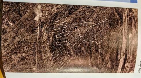
For larger geometric shapes, such as trapezoids, borders were marked and then all the stones on the interior were removed and placed along edges or heaped in piles at the edges of the geoglyph. Broken pottery has been found mixed with the piles of stones. Spirals and animal shapes were made in a similar manner. Spirals, for example, would be formed by releasing slack in a cord as workers moved around in a circular path, moving further and further from the center where the spiraling line begins. For animal forms, such as monkeys, whales, or hummingbirds, portions of the figures might be made in the same manner as the spiral in the monkey’s tail, or the image might be based on a gridded drawing or textile model that was enlarged on the desert floor where lines were staked out to create the figure.
When were they made?
The oldest of the Nasca Geoglyphs is more than 2000 years of old, but, as a group, the Nasca geoglyphs were created over several centuries, with some later lines or shapes intersecting or overlapping with previously created lines (Likely the Paracas Culture). This is just one of the unusual features of these geoglyphs. Even more curious, the drawings are best observed from the air, which is why they did not become widely known until the 1920s after the development of flight. Although it is possible to observe some of the lines from the adjacent Andean foothills or the modern mirador (viewing platform), the best way to see the lines today remains a flight in a small plane over the Pampa (lowlands). These amazing images are so large that they cannot be truly appreciated from the ground. This, of course, raises the question: for whom were the lines made? And, what was their purpose?

Monkey with Spiral Tail, Nasca Geoglyph, approximately 2000 years old (photo: Diego Delso, CC BY-SA 4.0)
What was their purpose and meaning?
Archaeologists are not certain of the purpose of the lines, or even of the audience for whom the lines were intended since they can only be seen clearly from the air (This is now particularly true of the older animal designs). Were they made to be seen by deities looking down from the heavens or from distant mountain tops? Perhaps the numerous theories that have been proposed will eventually be clarified as our understanding of the cultures of ancient Peru increases.
Celestial alignments?
Shortly after the geoglyphs were first investigated, researchers sought an astronomical interpretation, suggesting that the geoglyphs might be aligned with the heavens, and perhaps represented constellations or marked the solstices or planetary trajectories. While some geoglyphs seem connected to celestial events, such as marking the summer solstice (in December) when mountain waters flow to the coast, it is difficult to find celestial alignments for most of the geoglyphs. As far as we know, Andean peoples did not form pictures by connecting the stars in the night sky as we do; rather they looked at the black spaces between stars and saw shapes that they converted into their own reverse “constellations.” It is important to note that these constellations do not seem to match the Nasca geoglyphs.
Deities or ceremonial walkways?
Many other reasonable theories have been proposed. Some scholars have suggested that the geoglyphs represent Nasca deities, or formed a calendar for farming, or represented ceremonial walkways. Because some of the lines do seem to direct people to Cahuachi, a Nasca religious center and pilgrimage destination, it seems possible that ancient Nasca people walked the lines. It is also possible that Nasca people ritually danced on the lines, perhaps in connection with shamanism and the use of hallucinogens. The geoglyphs, particularly the early animals which are clearly spaced apart from each other, may also have strengthened group identity and reinforced social interaction patterns as individual groups of people may each have tended or “owned” one of the geoglyphs, perhaps ritually cleaning (sweeping) the pathways as part of the responsibility of ownership.

Spider, Nasca Geoglyph, over 300 feet in length, formed approximately 2000 years ago (photo: Diego Delso, CC BY-SA 4.0)
A discredited theory proposed that the geoglyphs are the result of alien contact. While this is sensationalist and helped to secure the popular fame of the Nasca geoglyphs, there is no evidence to support this assertion. Archaeologists and scientists have rejected this proposal and it is important to recognize the implication of this theory is that the Nasca people needed the influence of aliens peoples to create their geoglyphs. We know that the technology to manufacture the geoglyphs was available to the Nasca people and that they had a social system that was fully capable of organizing and producing large geoglyphs. We also know that the designs are consistent with other art forms native to Nasca culture.
Getting back to the TV show, it is the following explanation on which they were focusing.
Farming, fertility, and water?
Among the most promising recent theories, archaeologists have begun to secure a link between the geoglyphs and farming, which sustained the Nasca people. Some geoglyphs may deal with fertility for crops; others may be associated with the water needed to raise the crops. In a desert, water is the most important commodity. In Andean mythology the mountains are revered as the home of the gods. It has been suggested that the lines were intended to be visible to the gods in the mountains. Some lines also seem to point in the direction of the mountains—the origin of fresh water for the desert South Coast of Peru. Snow pack melts high in the mountains and becomes runoff and a vital source of water for the coast. In fact, ancient underground water channels are sometimes marked on the surface by Nasca geoglyphs, particularly at the points of intersection. These have been dubbed “ray centers,” spots where lines converge. Offerings have been found at these points, including conch shells. The spirals on the desert floor, in the monkey’s tail, and as independent abstract designs, may refer to the spirals found in conch shells and thus may reference water. This same shape appears in Nasca puquios—gradually descending tunnels that tap ancient subterranean aquifers and water channels. Puquios have been described as wells, and formed part of this ancient irrigation system. Puquios, found in Nasca (and elsewhere in Peru), allowed people to reach water in times of drought. Geoglyphs other than spirals may also be directly associated with water.

Puquio, South Coast of Peru
In the end, it is likely that the Nasca Geoglyphs served more than one purpose, and these purposes may have changed over the centuries, especially given that new lines often “erased” older ones by “drawing” over them. It does appear that many geoglyphs made reference to water and agricultural fertility, and were used to promote the welfare of the Nasca people. The geoglyphs were also a place where people gathered, perhaps for pilgrimage, perhaps to walk or dance on the lines in a ritual pattern. As a gathering place, the Nasca geoglyphs may additionally have turned the Pampa into a map of social divisions, where different families or clans tended different geoglyphs. Although we do not know exact details, we can surmise that the geoglyphs represent a community investment meant to serve this ancient people.
TV show also referenced the fact that the Nazca people likely were adding to designs and glyphs that had been put on the plain by an earlier people in the area, the Paracas Culture.
Paracas Culture
Paracas comes from the Quechua word para-ako meaning “sand falling like rain.” The Paracas culture flourished on the south Pacific coast of the central Andes in what is now Peru in around 600-150 B.C.E. and is one of the earliest known complex societies in South America. They were defeatedby the Nazca people and their culture integrated into that of the Nazca.
The Great Paracas Necropolis was discovered by archaeologists during the 1920s on the south Pacific Coast of the Central Andes. It is a vast communal burial site holding 420 bodies, which dates to around 300-200 B.C.E.
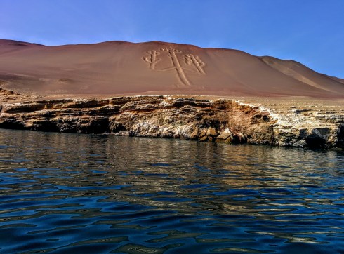
Saw the Candelabra on the way to the Ballestas Islands.
The Paracas Candelabra, also called the Candelabra of the Andes, is a well-known prehistoric geoglyph found on the northern face of the Paracas Penninsula in Pisco Bay. Pottery found nearby has been radio carboned dated to 210BC, the time of the Paracas Culture. The design is cut two feet into the soil, with stones possibly from a later date placed around it. The figure is 595 feet tall, large enough to be seen 12 miles at sea.
From Wikipedia
“The reason for the Candelabra’s creation is also unknown, although it is most likely a representation of the trident, a lightning rod of the god Viracoche who was seen in mythology throughout South America. It has been suggested that the Candelabra was built as a sign to sailors, or even as a symbolic representation of a hallucinogenic plant called Jimsonweed!
On a closing note, I realize as I age how much I am like my Dad in many respects. I never really got to know him as he died when I was only 33 and how many 33 year olds are having lenghty discussions with their Dad….how I wish he had remained in my life for a much longer time. He did however instill in me a life long passion for learning anout everything and anything and doing it anywhere.
I also have to thank my Anthropology 100 Professor at the University of Alberta…Dr. Bryant….who first introduced me to Indigenous People and their cultures in a course entitled “North America Indians”….doubt it would be called that today….I never missed his class and in those days classes were.. held Tues/Thurs/Sat at 9:00AM. I grew up in times when there were limited occupations open to women and never pursued my developing interest in Anthropology and Archaeology, very broad fields of study as I would come to learn…..years later much of what I leaned in those course have fostered continual learning and world travel, to enable me to see things first hand.
Back to those early connections I referenced in my opening…“Strange, isn’t it, how somethings we encounter in our early lives keep cropping up over time.” In retirement it has been the Royal Alberta Museum and the Telus World of Science that have brought me some of the best times in my volunteer career……not bad for an ARTS GRADUATE who celebrates her 50th Anniversary…..graduated University of Alberta in June 1967.


